Vegetated Swales
- teamcity (Deactivated)
- SysAdmin eWater
- Former user (Deleted)
- asatheesh (Unlicensed)
Vegetated swales are open channel systems which utilise vegetation to aid removal of suspended solids. As for buffer strips, the vegetation can assist in reducing peak flows for a range of events (dependent on the swale width and length) and may also be beneficial in volumetric reduction through infiltration, dependent upon the underlying soil conditions. These systems are subjected to fairly high hydraulic loading and the removal efficiency is dependent on the density and height of the vegetation in the channel.
A conceptual diagram of the swale properties in MUSIC is presented below:
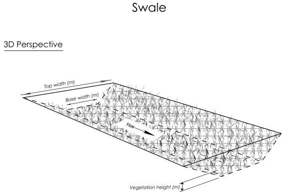
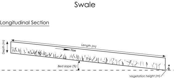
Conceptual diagram of swale properties.
Swale Properties
Flow in a vegetated swale is modelled in the USTM as uniform flow in a trapezoidal channel (although a triangular channel can be simulated by setting the base width to 0m).
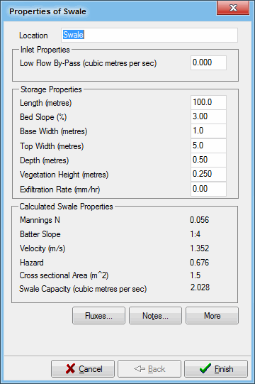
Location
The location name will be displayed under the vegetated swale node icon on the main worksheet.
Inlet Properties
Low Flow Bypass
All of the stormwater that approaches the swale below the user-defined Low Flow Bypass amount (in units of m3/s) will bypass the swale. Any flow above the Low Flow Bypass (up to the defined capacity of the swale) will enter and be treated by the swale.
 Tip Box
You do not need to set a high flow bypass for a swale. music will calculate the capacity of the swale for the given dimensions and vegetation. Inflow in excess of the calculated capacity will be treated as a high flow bypass.
Storage Properties
The storage properties describe the physical characteristics of the vegetated swale and are used to determine the water depth versus discharge relationship, which is used in the hydrologic routing of stormwater runoff through the swale.
Length
Defines the total length of the vegetated swale in metres.
Bed Slope
Defines the longitudinal slope of the swale as a percentage.
Base Width
Defines the width of the base of the trapezoidal channel in metres.
Top Width
Defines the width of the top of the trapezoidal channel in metres.
Depth
Defines the depth of flow to the top of the channel in metres. When the stormwater flow reaches a depth that exceeds this value, flow begins to bypass the vegetated swale, and only a flow rate equal to this flow will be treated by the swale. All of the stormwater flow in excess of this flow rate will bypass the swale and will not be treated by the swale.
Vegetation Height
Defines the height of the vegetation growing in the swale in metres. The vegetation height is used with a set of empirical relationships to determine the Manning’s n roughness of the trapezoidal channel (refer to Appendix V).
Exfiltration Rate
Exfiltration from the vegetated swale into the underlying soil can be modelled by defining the exfiltration rate (mm/hr). Representative exfiltration rates for different soil types are provided in the table below. The water that seeps from the vegetated swale is lost from the catchment, and cannot re-enter the system downstream. Contaminants in the water that is lost to exfiltration are removed from the vegetated swale, along with the exfiltrated water and are also lost from the catchment. Representative exfiltration rates for different soil types are shown in the following table.
| Soil Type | Median particle size (mm) | Saturated Hydraulic Conductivity | |
|---|---|---|---|
| (mm/hr) | (m/s) | ||
| Gravel | 2 | 36000 | 1x10⁻² |
| Coarse sand | 1 | 3600 | 1x10⁻³ |
| Sand | 0.7 | 360 | 1x10⁻⁴ |
| Sandy loam | 0.45 | 180 | 5x10⁻⁵ |
| Sandy clay | 0.01 | 36 | 1x10⁻⁵ |
Calculated Swale Properties
These are additional properties of the swale that are calculated automatically.
Mannings N
The Manning’s n roughness of the vegetated channel is determined from the vegetation height, based on work described by Kouwen (1988), Kouwen and Li (1980) and Kouwen and Unny (1973). A more detailed discussion of the algorithm is given in Calculating Manning's n in Swales.
Batter Slope
Slope of the side of the channel. Note that this must not be confused with the slope of the actual channel.
Velocity
Speed with which flow travels down the swale. calculated using Manning's formula.
Hazard
This is Velocity•Depth.
Cross sectional Area
The cross-sectional area of the swale.
Swale Capacity
This is also known as high flow bypass. music calculates the capacity of the swale for the given dimensions and vegetation. Inflow in excess of the calculated capacity is treated as a high flow bypass.

It is possible to record flux data for the swale:
- inflow rate and water quality
- outflow rate and water quality
- low flow bypass and water quality
- overflow rate and water quality
- total outflow rate (sum of outflow, bypass flows and overflow) and water quality
- computed water levels and storage.
Refer to Fluxes for more information about fluxes.

The Notes button allows you to record any important details or assumptions for the swale (for example, you may provide an explanation of how the vegetation height was estimated). It is good practice to provide notes of any important assumptions, for future reference by others using the model.
Advanced Swale Properties
The advanced properties section (opened using the ‘More’ button) of the swale properties dialogue box displays the parameters that describe the treatment processes in the swale as shown below.
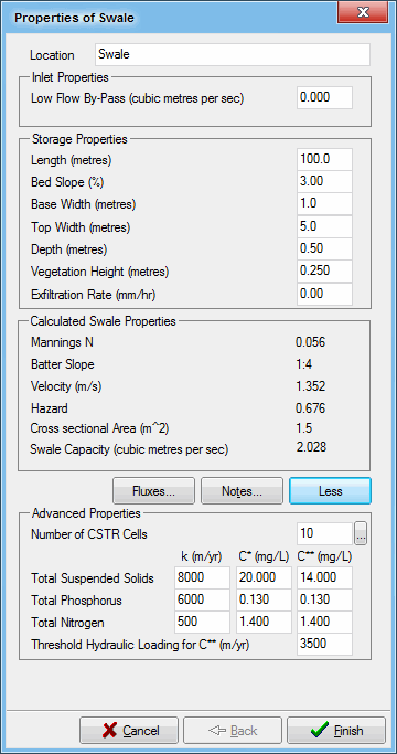
For details on configuring CSTR cells, refer to Number of CSTR Cells. An infinite number of CSTRs would replicate the effects of plug flow through the swale. music defaults to 10 CSTR cells for swales as most swales are relatively long and thin, however, as the shape of the system can vary markedly dependent on design, the number of CSTR cells that is required to represent the hydraulic efficiency of the design is dependent on that shape.
For swales:
- k and C* - The rate at which each contaminant is treated, and the background concentration for each contaminant will be different within a vegetated swale and different values should be adopted for each contaminant.